Reinebringen Hike: Sherpa Stairs Above Reine, Lofoten

Mountain peak above Reine with nearly 2000 stairs, offering panoramic views of the fishing village.

🚗 Access: hiking☀️ Season: all-year
💰 Entry: Free🅿️ Parking: Free
📍 Location: Northern Norway
Difficulty:hard, moderate
Time:2-3 hours
From parking:2–3 km hike
Kids:15+; under 15 only if carried.
Where to stay near Reinebringen
Closest cities for an overnight stay and approximate prices on Booking.com.
Campsites near Reinebringen
Nearest campsites and caravan sites — straight-line distance.
Loading map…
Reinebringen route map — parking, trailhead and viewpoint
Elevation profile
2.33 km13454 m452 m19 m
Weather now
Loading…

Quick answers

How many steps does the Reinebringen hike have?

The Reinebringen staircase — the Sherpatrappa — has roughly 1,978 stone steps (counts between about 1,974 and 1,978 are reported as steps are maintained). They run almost continuously from the foot of the slope to the viewpoint, so you climb nearly two thousand steps with very little flat ground in between.

How hard is the Reinebringen hike, and how long does it take?

Short but demanding. It is only about 1.1 km of climbing to the viewpoint, but you gain around 448 metres almost entirely on steps — one of the most physically taxing of Lofoten's "easy" hikes. Most people reach the viewpoint in 45 minutes to an hour, and the full round trip from the parking takes about 2 to 3 hours. It is easy if you hike often, and hard if you are not used to long stair climbs.

Where do I park for the Reinebringen hike?

The free Reinebringen parking is at Steffenakken (also signed Djupfjord), on the E10 about 1.3 km south of the trailhead — from there you walk back along the road to the foot of the stairs. It is small and fills up early in the summer high season, so come first thing in the morning or late in the day; in peak times you may have to wait for a space. There are also paid car parks closer to the trailhead and in Reine (around 40–50 NOK per hour) if the free lot is full.

Is the Reinebringen hike suitable for kids?

Locals and mountain guides generally do not recommend Reinebringen for small children — the climb is steep and relentless, the viewpoint area is small and gets crowded, and the slope beside the steps is unforgiving. That said, from our own experience it is possible: the Gowme.travel team climbed Reinebringen with our small child in a dedicated child-carrier backpack and reached the viewpoint together. It was not easy — carrying a child up close to two thousand stone steps is serious physical work — but it is achievable. The limiting factor is the parents' fitness, not the child; if you are not used to long stair climbs with extra weight, this is not the hike to test that on.

Who built the Reinebringen stairs?

Professional Sherpas from Nepal — the stoneworkers who build and maintain trails in the Himalaya — were hired by the local authority to lay the stone staircase. The work was done in stages between 2016 and 2021, both to make the climb safe for the huge number of visitors and to stop the original path from eroding the mountainside.

When is the best time to hike Reinebringen?

Late spring through autumn, when the stone steps are dry and clear. Summer brings the midnight sun and the famous evening light over Reine, but also the biggest crowds and the parking squeeze. In winter the staircase is covered in snow and ice and becomes a serious mountaineering objective — local guides discourage it for casual visitors.

Can I reach the actual summit of Reinebringen?

The Sherpa stairs end at a wide viewpoint on the mountain's shoulder — that is the destination for almost everyone and where the iconic photo is taken. The true summit lies further along a narrow, exposed and unsecured ridge beyond the steps. That section is genuinely dangerous and is not part of the normal hike; treat the top of the stairs as the end of the route.

About Reinebringen

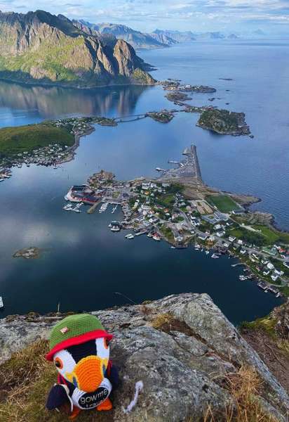
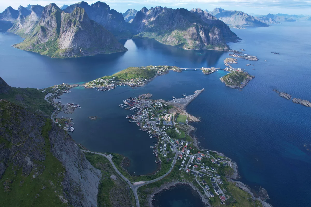
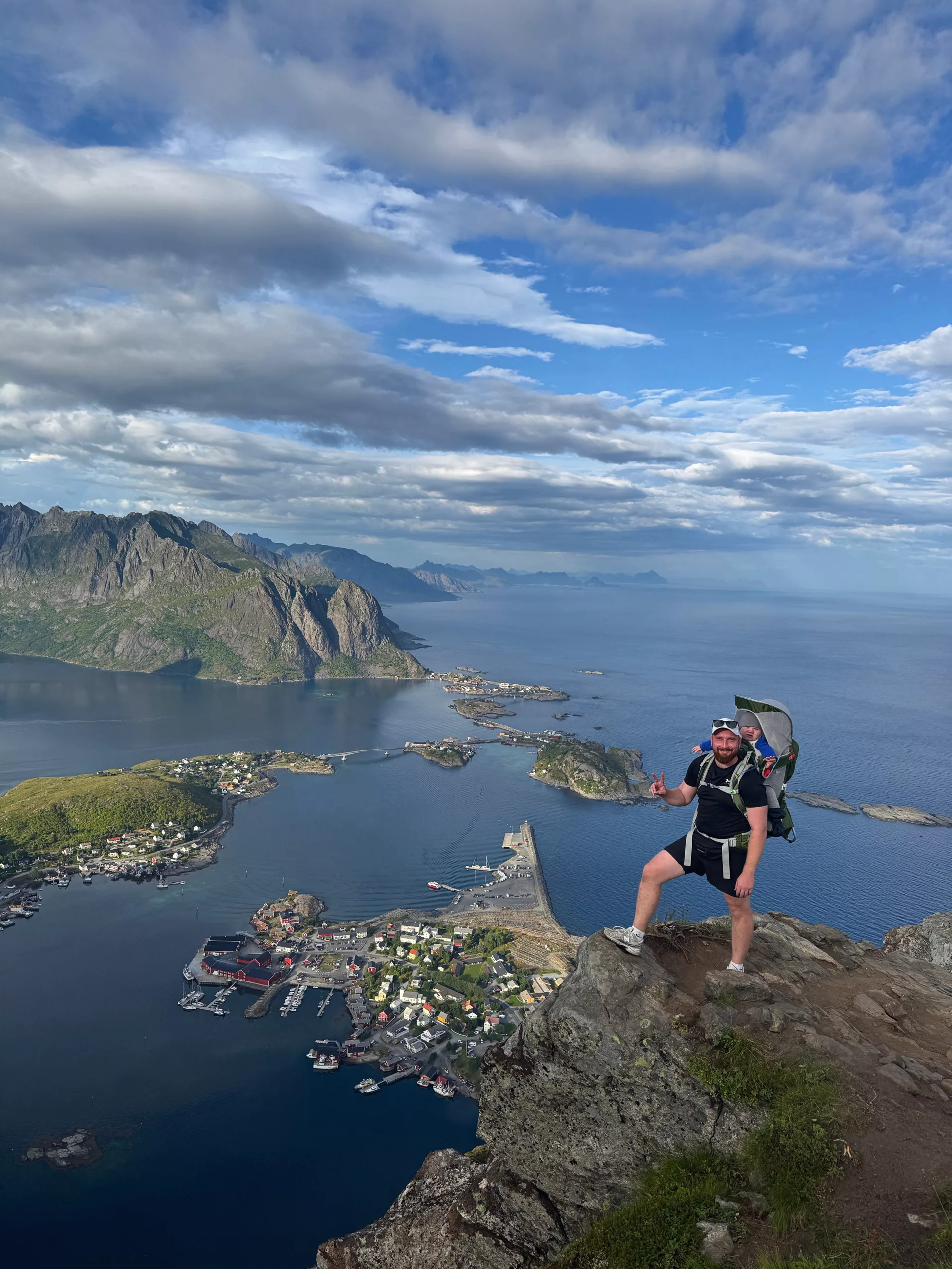
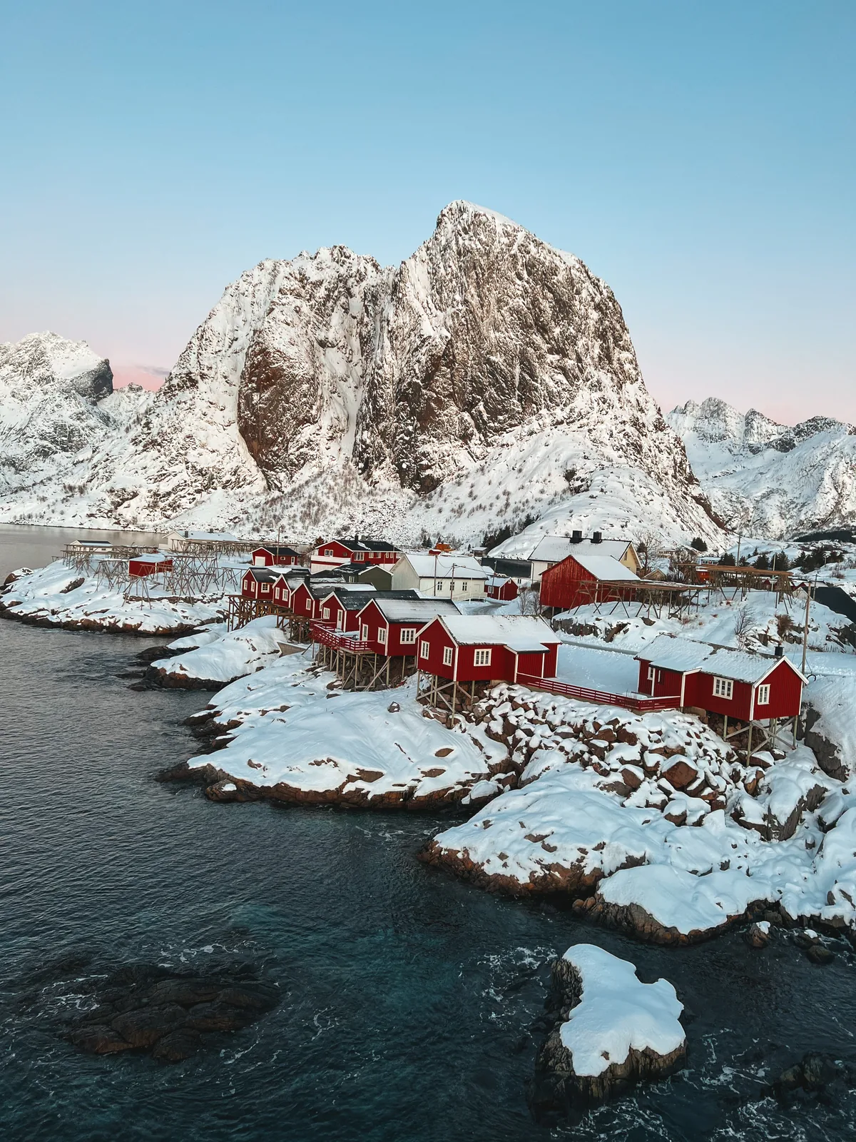
Reinebringen is a 448-metre mountain that rises almost straight out of the sea above the fishing village of Reine, in the Moskenes part of the Lofoten archipelago. It is a small mountain by Norwegian standards, but the view from its shoulder is arguably the single most photographed scene in Lofoten: the red and white rorbu cabins of Reine scattered across green islets, the still water of the Reinefjord, and a ring of sharp granite peaks closing the horizon. That view is the entire reason the trail exists in the form it does today.

For years the route up Reinebringen was a problem. The mountain is steep and the slope below the viewpoint is loose and grassy; as Lofoten tourism grew, thousands of people a year were scrambling up an eroding, increasingly dangerous path. The local authority's answer was unusual — it hired professional Sherpas from Nepal, the same stoneworkers who build and maintain mountain trails in the Himalaya, to lay a stone staircase straight up the mountainside. The work ran in stages from 2016 to 2021. The result is the Sherpatrappa, the Sherpa stairs: roughly 1,978 hand-built stone steps that carry you from the foot of the slope almost all the way to the viewpoint.

The hike today is short and brutally simple. From the trailhead it is only about 1.1 kilometres of actual climbing, but in that distance you gain around 448 metres of height — almost entirely on steps. There is no flat stretch and no easing-off: it is stairs from bottom to top. Most hikers reach the viewpoint in 45 minutes to an hour, and complete the full round trip — including the walk along the road from the parking — in roughly 2 to 3 hours.

Difficulty is where Reinebringen surprises people. On paper it looks easy: a built staircase, no navigation, no exposure on the standard route. In practice it is one of the most physically demanding of Lofoten's "easy" hikes. Climbing close to two thousand steep stone steps without a break is hard cardiovascular work, and the descent puts real strain on the knees. It is genuinely easy only if you hike regularly; for most visitors it is moderate, and for anyone unused to long stair climbs it is hard.

The stone steps end at a broad viewpoint on the mountain's shoulder — this is where almost everyone stops, and where the famous photograph is taken. The true summit of Reinebringen lies further along a narrow, exposed ridge beyond the steps. That continuation is unsecured and genuinely dangerous; it is not part of the normal hike, and most visitors should treat the stair-top viewpoint as the destination.

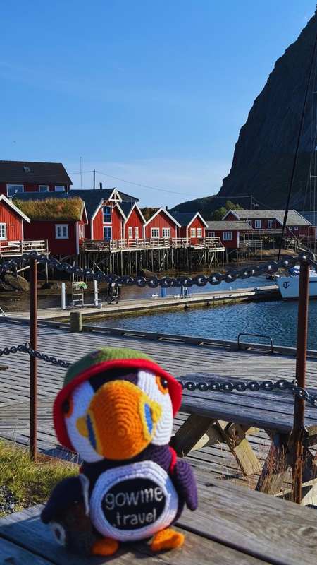
Reine itself, spread over islets at the mouth of the Reinefjord, is one of the most striking villages in Lofoten and a worthwhile stop in its own right. The one real headache of the hike is parking: the trailhead sits on the narrow E10 road with very little space, and in the summer high season the small free car park fills early. The stairs are a summer route — from roughly late spring through autumn the steps are dry and the climb is straightforward; in winter, snow and ice turn the same staircase into a serious, slip-prone mountaineering objective that local guides discourage for casual visitors.

9-day weather forecast — Reinebringen, Reine

Loading forecast…
Mountain weather changes fast. This is an automated forecast from MET Norway — not a personal recommendation. Check yr.no and use your own judgement before you head out.

Did you know?

  • Reinebringen's roughly 1,978 stone steps were hand-built by Nepalese Sherpas between 2016 and 2021.
  • The view from Reinebringen — Reine's red cabins below the Reinefjord — is one of the most photographed scenes in all of Norway.
  • Before the Sherpa stairs were built, the original Reinebringen path was so eroded and steep that the authorities openly discouraged the climb.

Practical tips

Footwear: hiking shoes with good grip. The stone steps become slippery when wet, and the long descent is where most slips happen.

Clothing: dress in layers and always pack a rain jacket and a windbreaker. The staircase and the viewpoint are fully exposed — Lofoten weather can swing from sun to cold, wind-driven rain within a single hike.

Food and water: bring water (there is none on the route) and energy snacks for the climb — a Kvikk Lunsj or another chocolate or cereal bar is the classic Norwegian trail fuel, and the viewpoint is the perfect place to stop and refuel.

Fitness and pace: this is a short hike but an almost non-stop stair climb of nearly 2,000 steps. Set a slow, steady pace, take breaks on the benches built into the staircase, and do not underestimate the descent — trekking poles noticeably ease the load on your knees.

Conditions: check the forecast before you start. Skip the climb in heavy rain, strong wind, snow or ice, when the stone steps become genuinely dangerous.

Nearby places

Plan your Norway trip in one smart map

Fluffy™ Norway Trip Planner is built for one thing: turning a messy "somewhere in Norway" idea into a clear route you can actually follow. Tell Fluffy when you're traveling, who you're with, how active you want to be – and the planner curates a custom mix of fjords, viewpoints, easy walks and bigger adventures.

Whether you're starting with classic Oslo attractions and day trips from Oslo, flying to Bergen for some Bergen sightseeing, or chasing the northern lights around Tromsø, Bodø, Narvik or Alta, the planner connects it all into one route. Road-tripping through western Norway around Aurland, Gudvangen, Loen, Olden, Voss and Stryn? Hopping between islands in Lofoten – Svolvær, Leknes, Å i Lofoten, Henningsvær, Hamnøy? Or mixing cities like Stavanger, Trondheim, Kristiansand and Lillehammer with quiet fjord villages? Fluffy keeps the puzzle pieces in order.

After five quick steps, you get a personalized map of Norway with recommended places across northern, western and southern Norway – sent straight to Google Maps. Open it on your phone, tick off spots as you go, and adjust on the fly. You bring the curiosity; Fluffy brings the map.

Show more