Kvalvika Beach & Ryten Hike, Lofoten

Mountain peak in Lofoten offering views of Kvalvika Beach and surrounding fjords.

🚗 Access: hiking☀️ Season: all-year
💰 Entry: Free🅿️ Parking: Free
📍 Location: Northern Norway
Difficulty:moderate
Time:3-5 hours
From parking:3–4 km hike
Kids:15+; under 15 only if carried.
Where to stay near Kvalvika Beach + Ryten
Closest cities for an overnight stay and approximate prices on Booking.com.
Campsites near Kvalvika Beach + Ryten
Nearest campsites and caravan sites — straight-line distance.
Loading map…
Kvalvika Beach and Ryten route map — parking options, trail variants and viewpoint
Elevation profile
Ryten
Kvalvika Beach
8.11 km1490 m673 m673 m
Weather now
Loading…

Quick verdict

⏱️ Time needed
About 1.5–2 hours for Kvalvika Beach only, or around 4–5 hours for the full Ryten and Kvalvika combination.
✅ Worth it if
You want one of Lofoten's wildest beaches and, if you continue to Ryten, one of the most famous top-down viewpoints in the islands.
⚠️ Skip if
You do not want any uphill hiking and are not interested in either a beach walk or a longer mountain viewpoint route.

Quick answers

When is the best time to hike to Kvalvika Beach and Ryten?

Late May to September is the easiest window: the paths are mostly dry, the days are long, and from late May to mid-July the midnight sun lets you walk to the beach late in the evening with the sand almost to yourself. The hike is also possible in winter — the Gowme.travel team did it in deep snow back in 2022, and the white, silent version of Kvalvika with the view from Ryten over the beach was one of the most unforgettable walks we have done in Lofoten — but winter here means short daylight, snow on the trail and avalanche-aware caution on the Ryten side, so it is not a casual outing. For a first visit, come in summer.

How hard is the Kvalvika Beach and Ryten hike, and how long does it take?

It depends on how much of it you do — and you choose. Reaching Kvalvika Beach on its own is the easy option: about 40 to 45 minutes each way over a low pass, and a popular outing in its own right if you do not want the climb. The full loop — parking, up to Ryten, down to Kvalvika Beach and back — is graded moderate: about 8.1 km with around 670 m of total ascent, taking most hikers 4 to 5 hours with stops. The Ryten leg is the demanding part: a steeper, longer climb to the 543-metre summit shoulder. Nothing is technical, but the bare-earth paths get muddy and slippery after rain, so allow extra time in wet weather.

What should I wear and bring for the Kvalvika and Ryten hike?

Proper hiking shoes with good grip are the single most important item — the Kvalvika and Ryten paths are bare earth, not stone or boardwalk, and turn muddy and slippery after rain, especially on the descent. Dress in layers with a windproof, waterproof shell, because the pass and the Ryten summit shoulder are fully exposed and the weather off the open sea changes quickly. Bring water and a snack — there is nothing to buy along the route.

Where is the parking for Ryten and Kvalvika Beach?

There are three car parks, and in summer all of them fill early. We recommend starting from the free Fredvang-side parking, which has the most spaces of the free lots — though "most" is still small. A second free parking is nearby but has the fewest spaces of all. If both are full, or you are travelling by campervan, use the larger paid car park (around 100 NOK), which has its own slightly different starting point and trail. Important: never park with any wheel on the road. The Fredvang area is actively patrolled in summer — in 2025 we repeatedly saw enforcement vehicles issuing tickets — and a wrongly parked car is a fine of 660 NOK or more. The ground also drops away steeply beside the road, so the verge is unsafe as well as illegal.

Is the Kvalvika Beach and Ryten hike suitable for kids?

The walk to Kvalvika Beach itself is manageable for children who are used to walking uphill — it is short, with just one real climb — and the beach is a wonderful reward. The Ryten leg is harder and steeper and the summit shoulder is exposed, so it asks more of a child. Smaller children should be carried in a proper child-carrier backpack rather than walked or held by the hand, particularly on the muddy sections and anywhere near the Ryten edge. A note from our own experience: in summer 2025 the Gowme.travel team set out with a baby under one year old in a carrier backpack and turned back before the finish when heavy rain made the trail unsafe — with a small child that call is an easy one to make, and we are simply saving the rest of Kvalvika and Ryten for our next trip.

How much does the Kvalvika Beach and Ryten hike cost?

The hike itself is free — there is no fee for the beach or the mountain. The only cost is parking, and it depends which car park you use. The two small car parks on the Fredvang side are free; the larger, more campervan-friendly car park is paid, at around 100 NOK. Budget nothing more than that — but do budget time to find a space, because in high summer the free lots fill very early.

What can you see at Kvalvika Beach and from Ryten?

Kvalvika Beach is a broad curve of pale sand between steep green mountains, open straight onto the Norwegian Sea — a wild, road-free beach that featured in the documentary North of the Sun. Climb the Ryten hike above it and the whole scene opens up: from the 543-metre summit shoulder you look straight down onto the turquoise water and white sand of Kvalvika, with the outer Lofoten coastline and open ocean beyond. The overhanging rock ledge near the top of Ryten is the classic photo spot — and, on a clear summer evening, one of the best places in Lofoten to watch the midnight sun.

Is Kvalvika Beach worth it without hiking Ryten?

Yes. Kvalvika alone is worth visiting if you want an easier walk and one of the wildest and most beautiful beaches in Lofoten.

Do you need to hike Ryten, or is Kvalvika enough?

Kvalvika is enough if your goal is the beach itself. Ryten is the better choice if you want the famous high view looking down over Kvalvika.

What is the famous photo spot on the Ryten hike?

Near the top there is a rock ledge that many visitors use for photos, often compared to a mini Trolltunga-style photo moment.

How does parking work in summer at Kvalvika and Ryten?

In summer, parking can fill up and you may need to wait for a space. If your schedule allows it, late-evening hiking during the midnight sun period can be a very good alternative.

How is Kvalvika easier than Ryten for families?

Kvalvika is the easier option because it gives you the beach experience without adding the steeper climb needed for the Ryten viewpoint.

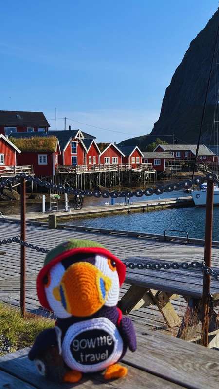
About Kvalvika Beach + Ryten

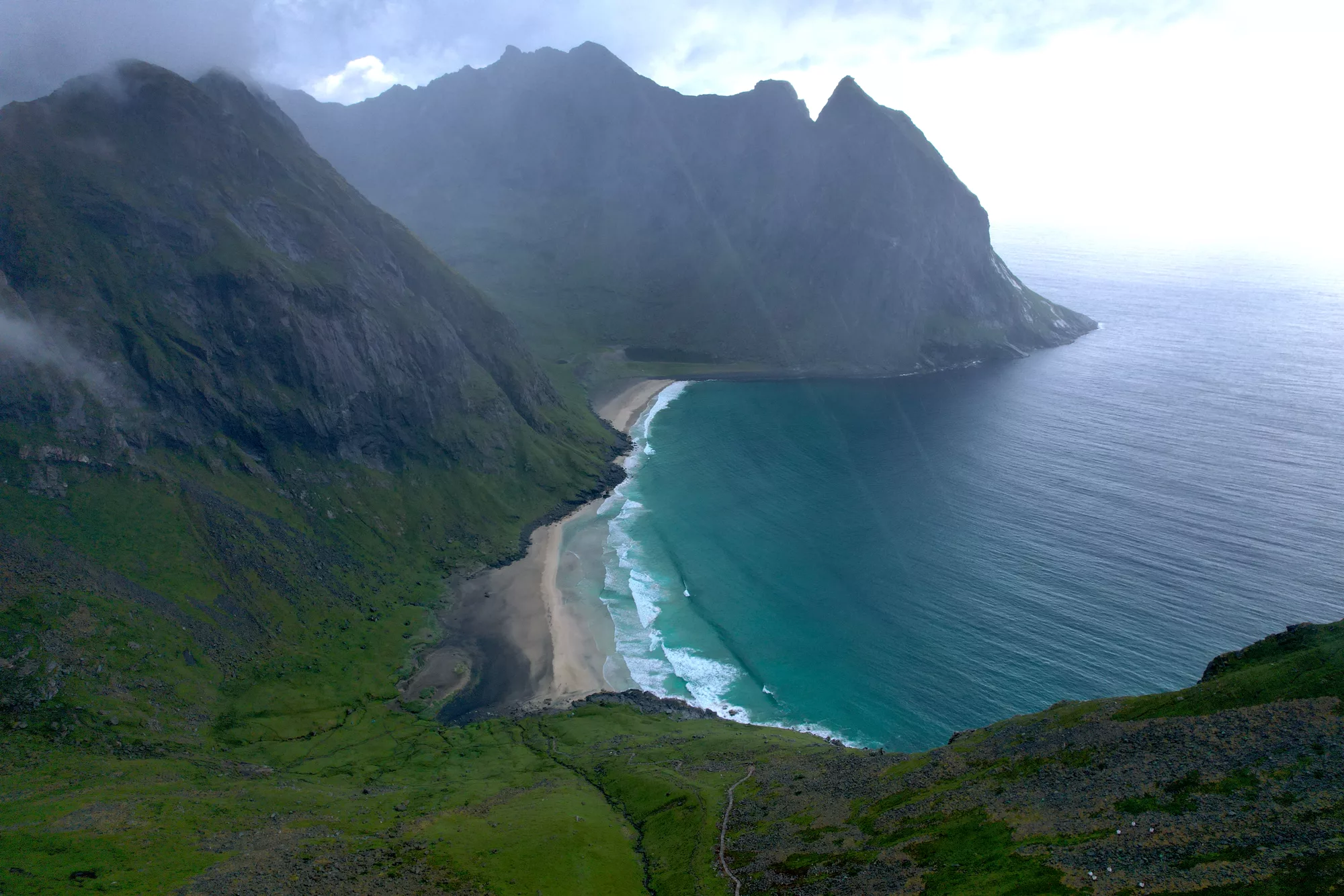
Kvalvika Beach is one of the most striking places in Lofoten — a wide arc of pale sand wrapped between steep green mountains on the outer, ocean-facing side of Moskenesøya, near the village of Fredvang. No road reaches it. The only way in is on foot, over a low mountain pass, and that short walk is exactly what keeps the beach quiet even at the height of the Lofoten summer.

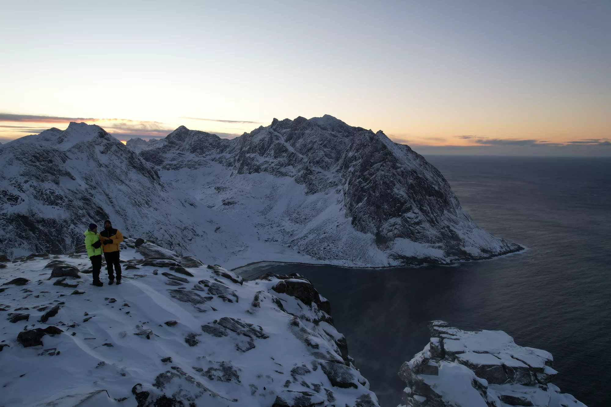
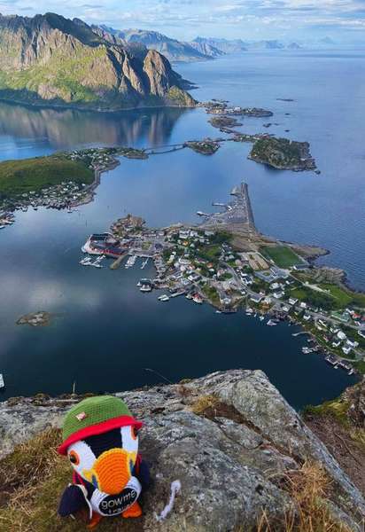
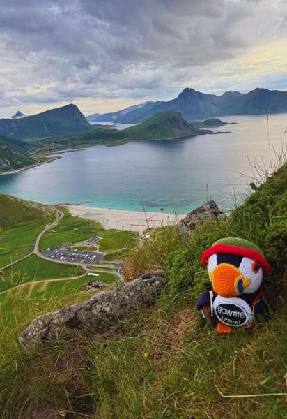
There are really two destinations here — the beach and the summit — and they link into one circular route. From the free parking on the Fredvang side you climb first to Ryten — a 543-metre mountain whose flat summit shoulder hangs almost directly above the beach — then drop down the far side to Kvalvika Beach, and finally loop back over the pass to the car. The view from Ryten down onto Kvalvika — turquoise water, white sand, the open Norwegian Sea — is one of the most photographed scenes in all of Lofoten, and the famous overhanging rock ledge near the top of Ryten is where most of those photos are taken.

You do not have to do the whole loop, though — and that is the nice thing about Kvalvika. If the climb does not appeal, walk only to Kvalvika Beach and back over the pass: a much gentler outing of roughly 1.5 to 2 hours that still puts you on that wild stretch of sand, with no summit involved. If it is the famous high view you are after, head up Ryten. And if you want both, do the full loop — parking, up to Ryten, down to the beach and back — around 8 km, 4 to 5 hours for most walkers. Pick whatever suits you; there is no wrong choice. The exact distance and elevation gain are on the trail map below.

Kvalvika has a quiet claim to fame. In 2010–11 two young Norwegian surfers, Inge Wegge and Jørn Ranum, spent nine winter months living on the beach in a cabin they built from driftwood washed up on the sand. The film they made of it, North of the Sun (Nordfor sola, 2012), won awards around the world and turned this hidden beach into a bucket-list stop. The driftwood cabin is long gone, but the sense of a place at the edge of things is still very much there.

The Ryten hike and the beach trail are not technical, but they earn the moderate grade. The paths are bare earth and, after rain, genuinely muddy and slippery — both the climb to the pass and the descent. The Ryten leg is steeper and longer and rewards sure footing, especially in wind near the exposed summit shoulder. Good hiking shoes matter here more than raw fitness.

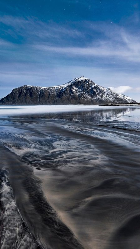
The walk is doable year-round, but it changes completely with the seasons. From late May through September the paths are mostly dry and the days are endless — the midnight sun makes a late-evening walk to Kvalvika Beach unforgettable. In winter the same route becomes a snow hike: beautiful, but serious, with short daylight and real avalanche-aware caution needed on the Ryten side.

One practical thing dominates a Kvalvika trip: parking. There is no single official parking for Ryten and Kvalvika Beach — there are three separate car parks, and in summer all of them fill. The two free lots on the Fredvang side are small and the spaces are very limited; a third, larger car park is paid (around 100 NOK) and easier for campervans, with its own starting point. Whatever you do, do not improvise a roadside spot with wheels on the carriageway — the area is actively patrolled and the fines are steep (see the parking question below).

Kvalvika rewards an early start: arrive in the morning, take the beach slowly, climb Ryten for the view, and you have done one of the defining hikes of Lofoten.

9-day weather forecast — Kvalvika Beach + Ryten, Fredvang

Loading forecast…
Mountain weather changes fast. This is an automated forecast from MET Norway — not a personal recommendation. Check yr.no and use your own judgement before you head out.

Did you know?

  • Kvalvika Beach has no road — the only way to reach it is the walk over the mountain pass from the Fredvang side.
  • Surfers Inge Wegge and Jørn Ranum spent nine winter months in a driftwood cabin on Kvalvika in 2010–11, filming the award-winning documentary North of the Sun (2012).
  • Ryten rises 543 metres directly above Kvalvika Beach; its overhanging summit ledge is one of the most photographed viewpoints in Lofoten.

Practical tips

Footwear: hiking shoes with good grip and ankle support. The Kvalvika and Ryten paths are bare earth — after rain they turn properly muddy and slippery, and the Ryten descent is where most people lose their footing.

Parking and fines: park only in a marked bay, fully off the road. The Fredvang-side area is patrolled in summer and a wrongly parked car — even one wheel on the carriageway — is a fine of 660 NOK or more. Note that the ground drops away steeply right beside the road, so squeezing onto the verge is both illegal and genuinely unsafe.

Clothing: layers and a windproof, waterproof shell. The pass and the Ryten summit shoulder are fully exposed and the weather off the open sea changes fast.

Water and food: bring both — there is nothing on the route. Kvalvika Beach itself is the obvious place to stop and eat.

Combining hikes: Kvalvika sits among other Lofoten classics — it pairs well with the Sherpa-stair climb up Reinebringen and the short beach-to-summit Mannen hike at Haukland, both an easy drive away if you are building a Lofoten hiking trip.

Nearby places

Plan your Norway trip in one smart map

Fluffy™ Norway Trip Planner is built for one thing: turning a messy "somewhere in Norway" idea into a clear route you can actually follow. Tell Fluffy when you're traveling, who you're with, how active you want to be – and the planner curates a custom mix of fjords, viewpoints, easy walks and bigger adventures.

Whether you're starting with classic Oslo attractions and day trips from Oslo, flying to Bergen for some Bergen sightseeing, or chasing the northern lights around Tromsø, Bodø, Narvik or Alta, the planner connects it all into one route. Road-tripping through western Norway around Aurland, Gudvangen, Loen, Olden, Voss and Stryn? Hopping between islands in Lofoten – Svolvær, Leknes, Å i Lofoten, Henningsvær, Hamnøy? Or mixing cities like Stavanger, Trondheim, Kristiansand and Lillehammer with quiet fjord villages? Fluffy keeps the puzzle pieces in order.

After five quick steps, you get a personalized map of Norway with recommended places across northern, western and southern Norway – sent straight to Google Maps. Open it on your phone, tick off spots as you go, and adjust on the fly. You bring the curiosity; Fluffy brings the map.

Show more