Segla Hike via the Hesten Viewpoint, Senja
Fluffy at the Hesten viewpoint looking across to Segla — proof this page is built from our own trip to Senja.
Mountain peak on Senja island offering views of Segla and Medfjorden.
🚗 Access: hiking☀️ Season: all-year
💰 Entry: Free • 🅿️ Parking: 250 full day
📍 Location: Northern Norway
⚡Difficulty:moderate
⏱️Time:3-4 hours
👣From parking:2–3 km hike
👨👩👧Kids:15+; under 15 only if carried.
Where to stay near Hesten
Closest cities for an overnight stay and approximate prices on Booking.com.
Campsites near Hesten
Nearest campsites and caravan sites — straight-line distance.
🏕️ Camp near HestenSkaland Camping · ~13 km · ★★View campsite▼
Segla / Hesten route map — the Fjordgard trailhead parking and the viewpoint over Segla
Elevation profile
2.31 km25–473 m↗ 453 m↘ 13 m
Quick verdict
- ⏱️ Time needed
- About 3–4 hours round trip — roughly 2–3 km each way with around 520 m of climbing, plus plenty of time at the top for photos.
- ✅ Worth it if
- You want the single most iconic view on Senja — the sail-shaped Segla peak rising out of the fjord — and you're up for a short but constantly steep hike.
- ⚠️ Skip if
- The weather is wet or foggy (the view is the whole point and the rock gets slippery), or you can't manage a steady steep climb with a short rock scramble near the top.
Generate your personalised Norway locations for free
Every place in Norway you'd actually want to see — in under 2 minutes.
Generate free locationsQuick answers
Is the Segla hike the same as the Hesten hike?
Almost. The famous photo of Segla — the 639 m sail-shaped peak — is taken from the summit of the neighbouring mountain, Hesten (556 m). The marked, walkable trail from Fjordgard goes up Hesten, and that is the hike nearly everyone means by "the Segla hike". Climbing Segla itself is a steep, exposed scramble for experienced hikers only; from Hesten you simply look across at it.
How do I get to the Segla / Hesten trailhead on Senja?
The trailhead is at Fjordgard, a small village on Senja island. Senja is connected to the mainland by road, so no ferry is strictly required: from Tromsø, drive the E8 south and follow Fv862/86 west onto Senja, then the signs to Fjordgard (about 3–4 hours; the final approach runs through a long, narrow tunnel). In summer the seasonal Brensholmen–Botnhamn car ferry is a popular shortcut — about a 25-minute drive to the trailhead on the far side. Parking is in the lot behind the Fjordgard school.
How hard is the hike and how long does it take?
Moderate, but constantly steep from the bottom to the top. It is roughly 2–3 km each way with around 520 m of elevation gain, and there is a short rock scramble near the summit — not technical or badly exposed, but you need to watch your footing. Most visitors take about 3–4 hours round trip including photo stops (moving time is well under two hours). It gets slippery in the rain, so save it for a dry day.
Where do I park for the Segla hike?
In the large paid parking lot behind the Fjordgard school (Senja Montessoriskole). It costs roughly 100 NOK for 3 hours, or about 250 NOK for a full day, and the big lot has a good free toilet. There is also a small paid parking place at the end of the road in the village. Come early in the high season — Fjordgard is tiny and the trailhead parking fills up.
Is the Segla hike suitable for kids?
It is a steep climb with a short rock scramble near the top, so it is best for older children who already hike. Younger children must be carried in a proper child-carrier backpack — never in your arms — because the upper section has loose footing and the same ground is slippery on the way down. Skip it with kids in wet or foggy weather.
When is the best time to hike Segla, and what about insects?
Late spring to early autumn, when the rock is dry. The midnight sun shines on Senja from late May to mid-July, so you can hike late into the night in full daylight. Bring strong insect repellent in summer — hikers regularly report heavy horseflies and mosquitoes here that can genuinely make the climb harder. In winter the route becomes a serious snow-and-ice mountaineering objective.
Our experience
We hiked up to the Hesten viewpoint with our under-one-year-old in a child-carrier backpack — never carried in our arms, because the trail is steep the whole way and the loose ground near the top is no place for that. With a sturdy carrier and good shoes it was completely manageable as a family, and the view across to Segla at the top was worth every step.
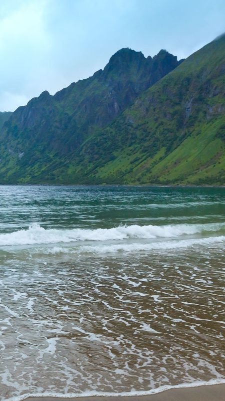
We did the hike at the end of August, and there was an unexpected bonus: down in the lowlands at the start of the route, before the steep climbing begins, we found ripe cloudberries (multebær) growing in the boggy ground — a prized Norwegian delicacy. Keep an eye out as you set off in late summer.
About Hesten
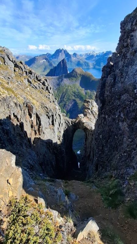
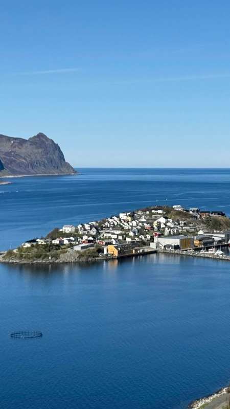
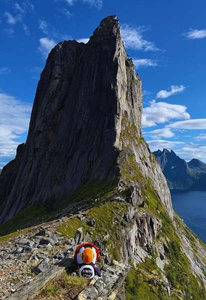
Segla is a 639-metre mountain on the island of Senja in Northern Norway, and one of the most photographed peaks in the country. Its near-vertical, sail-shaped face rises straight out of the water between Mefjorden and Ørnfjorden, just outside the small fishing village of Fjordgard — the silhouette is so distinctive that it has become the visual symbol of Senja itself.
The catch is that you do not get the famous view of Segla by climbing Segla. The iconic shot — the sheer "sail" standing over the fjord — is taken from the summit of the neighbouring mountain, Hesten (556 m). That is why almost everyone who comes to photograph Segla actually hikes Hesten: the marked trail from Fjordgard climbs Hesten and delivers you to a broad viewpoint looking straight across at Segla's dramatic face. Climbing Segla itself is a steep, exposed route for experienced scramblers only, and it is not the walk described here.
The Hesten trail starts from the parking lot behind the Fjordgard school and climbs steadily — and constantly — up the mountainside. There are no real flat sections: it is uphill from the first steps to the top, with around 520 metres of elevation gain over roughly two to three kilometres. The path is moderately demanding rather than technical, with no exposed drops until the very end, where a short rock scramble brings you onto the summit plateau. Many hikers stop a little below the true top, because the view across to Segla and down both fjords is already wide open from there — you genuinely do not need to go to the edge to take it in.
The summit is broad, with several vantage points giving slightly different angles over Segla, the fjords and the surrounding peaks of Senja's wild northern coast. There is enough flat ground that wild camping is popular here in summer, with the Segla view from the tent door as the reward. Most people spend far longer at the top than the climb itself takes — the round trip is usually three to four hours including photo stops, though the actual moving time is under two hours.
Senja is Norway's second-largest island and, unlike the outer Lofoten islands, it is reached by road: a bridge links it to the mainland, and Fjordgard sits at the end of a narrow mountainous peninsula reached through a long road tunnel. From Tromsø the drive is around three to four hours; in summer the Brensholmen–Botnhamn car ferry cuts the journey considerably. The trail is busiest from late spring through early autumn, when the rock is dry and the midnight sun keeps the mountain lit through the night. In those months, come prepared for insects — horseflies and mosquitoes around Fjordgard can be fierce and are the most common complaint from summer hikers. In late autumn and winter the same route turns into a serious snow-and-ice climb best left to experienced mountaineers.
9-day weather forecast — Hesten, Skaland
Loading forecast…
⚡
Mountain weather changes fast. This is an automated forecast from MET Norway — not a personal recommendation. Check
yr.no and use your own judgement before you head out.
Did you know?
- Segla rises 639 m almost straight out of the fjord — its sail-shaped face is the visual symbol of Senja.
- The classic view of Segla is taken from the neighbouring Hesten summit (556 m), not from Segla itself — Segla is a far more technical climb.
- The Hesten summit plateau is wide enough to pitch a tent, and wild camping with the Segla view is popular in summer.
Practical tips
Footwear: sturdy hiking shoes with good grip. The trail is steep the whole way and the short scramble near the top has loose rock; the descent is where most slips happen, and wet rock here is genuinely slippery.
Insects: in summer bring strong repellent. Horseflies and mosquitoes around Fjordgard are the single most common complaint from hikers and can make the climb noticeably harder.
Water and food: carry plenty of water — there are no streams on the route — and snacks for the top, where most people linger far longer than the climb takes.
Clothing: pack layers and a windproof shell. The summit is exposed and colder and windier than the trailhead, even on a warm day.
Weather and timing: this is a view hike — if it is foggy or raining, the payoff disappears and the rock gets slippery, so wait for a clear, dry day. Parking behind the Fjordgard school is small and fills early in the high season, so start in the morning or late evening.
Nearby places
Inste Kongen
Troms · 1.9 km away
Husøy Viewpoint
Northern Norway · 4.5 km away
Husøy Island
Troms · 4.5 km away
Husøy Lighthouse
Northern Norway · 4.6 km away
Ersfjord Beach
Troms · 8.3 km away